Nov 032021
 

 We have decided to do a side trip leaving the southern travel on hold for a week.  It’s been decided that we will anchor on the Tennessee River after the only lock of the Day.  We will be heading to Chattanooga, AL passing into the Smoky Mountains.  We have been to the Smokies in the past however that was a road trip.  The goal of the day is getting past the Pickwick Lock and Dam at a whopping 55 ft lift to Pickwick Lake.  The Lake of millionaire summer retreats. 

The homes and cottages are definitely becoming more prominent along the shoreline on the Tennessee River heading to the lock.  Most are built on stilts to protect from potential floods.  The bluffs made out of limestone and carved from the millennia of the river are stunning.  The tales they could tell.  In some cases we can see the history.  The limestone has given way and at least 3 homes, that we have seen, are swallowed up by the landslides.  The Kentucky red soil called Crider soil covers one half million acres over 35 counties in the state and can be found with the limestone when the landslides occur.  There are these trees that are hanging on by their roots in open water that resemble triangles. Left to their lonesome they stand picturesque on the shore with their booty showing. How do they survive the high waters?

It is difficult to show the scale of the size of these bluffs but if you find a boat or something to help with scale you can see just how tall they are.  The massive houses seem small given the mega houses beside some.  Having proximity to Nashville, Paducah and St. Louis this is an area that has some big estate properties. 

It’s a cold one today too.  We did keep the gen running for the heat all day.  The overcast skies and slight wind kept the temps low.  Tonight is will drop to 32 degrees, or 0 degrees C.  We plan on running the heat until bed then snuggling in blankets til morning where Scott will start her up again.

We have met up with 3 other boats and will be locking through with them.  The lock will be ready for us to head in once we are there.  It’s a good day.  Rounding the last bend in the river towards the lock another boat has joined in.  Now we are a team of 5.  Pickwick Lock is notorious for having delays so we are not unhappy about slow commercial traffic today.  We also made it to the Pickwick Lock facebook page. 

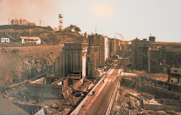
Pickwick: Facts & Figures

  • Construction of Pickwick Landing Dam began in 1934 and was completed in 1938.     
  • The dam is 113 feet high and stretches nearly a mile and a half across the Tennessee River.
  • Pickwick Dam is a hydroelectric facility. It has six generating units with a summer net dependable capacity of 247 megawatts. Net dependable capacity is the amount of power a dam can produce on an average day, minus the electricity used by the dam itself.
  • When Pickwick Reservoir is full during the summer, it has nearly 490 miles of winding shoreline and 43,100 acres of water surface.
  • Pickwick has a flood-storage capacity of 492,700 acre-feet.
  • To maintain the water depth required for navigation, the minimum winter elevation for the reservoir is 408 feet. The typical summer operating range is between 413 and 414 feet.             
  • The dam has two locks: One measures 110-by-600 feet and the other 110-by-1,000 feet.
  • Pickwick Landing Dam’s first turbine was the largest of its kind in the country when it was installed; its runner was more than 24 feet in diameter. New runners with a more efficient design were installed in the 1980s.   

After the lock we have about 10 miles to go to the anchorage at mile marker 211 on the Tennessee River.  It’s a large, deep anchorage tucked in a cove with hills and fall foliage around us.  Protected from winds in all directions this is one of our favourites. 

Nov 022021
 

Leaving the anchorage at mile marker 88 we are heading south out of Kentucky Lake where it will end and the Tennessee River will continue. Scott notes that the current is stronger at about 1 knt against us. In the narrower section it is running at 1.5 knts. The day started out cloudy and cold with last night dipping to under 50 degrees. The generator has been running since 6 AM and it is staying on until almost noon when the sun decided to show up.

The name of the river may have come from a Cherokee Indian village located on the Little Tennesse River and spelled variously Tanase, Tennassee, Tanasi, or Tinasse. The Tennessee was explored during the period of rivalry between the French and the English for the territory west of the Appalachians, and a few small forts and posts were established on its banks. Earlier, explorers and fur traders had entered the lower course of the river from the Ohio River. Although the Tennessee served as a route for settlers moving southwestward, its role as a westward passage was negligible compared with that of the Ohio.

Originally, the Tennessee could be navigated only by flatboats. Its upper course was shallow and filled with short rapids. Its middle course, through the Cumberlands, contained whirlpools and was interrupted by muscle shoals (rapids, now submerged by reservoirs) in Alabama. Only its lower course was easily navigable, but the advent of the railroads in the Tennessee River valley after the 1840s kept river traffic from assuming the significance it had on other western and more easily navigated rivers.

The river’s north-flowing lower course was strategically important during the Civil War, for its valley offered an invasion route into the western Confederacy. Part of the course downstream is paralleled by theCumberland River. The Confederate forts Henry (on the Tennessee) and Donelson (on the Cumberland) were only 12 miles (19 km) apart. General Ulyssess S. Grant Federal army, accompanied by gunboats, struck southward in the Tennessee River valley in February 1862. The Confederate forces fell back to Corinth, Mississippi, and the Federal troops moved almost to Tennessee state’s southern boundary, where the Battle of Shiloh (Pittsburgh Landing) was fought (April 6–7, 1862).

The development of the river system as an important inland waterways began in 1933 with the establishment of the Tennessee Valley Authority. The Tennessee now has a series of locks and reservoirs impounded by multipurpose dams for navigation, power, and flood control. 

We are heading into another anchorage just north of Shiloh National Park where some 23,000 men perished in the civil war. At mile marker 154 we drop the hook at Beech Creek Island and find our charts and the water level are similar. The purposely lowered levels are not a problem. We anchor in about 25 feet and put out a long chain. The winds are soft and the current keeps us in line. It is another glorious night on anchor as I write and Scott pulls out manuals and reads on the back deck.

Nov 012021
 

Leaving Green Turtle Marina the river you enter is the Cumberland River. It will take you to Nashville which is a beautiful trip that we had done previously. The Cumberland River (Barkey Lake) and the Tennessee River are connected by a dug canal called “the land between the lakes” because the waters from both these lakes are on either side connected by the canal. We make a turn onto the canal to head into the Tennessee River and Kentucky Lake. The 2 names are synonomous as they are the same body of water.

The history of the Kentucky Lakes Area is really amazing. Throughout the area, there is evidence of settlements dating back 8,000 years. Indian mounds dating to 1,000 years ago can be seen throughout the area and with the Tennessee Valley Authority creating Kentucky Lake and Land Between The Lakes in the mid 20th century, many modern-day archaeology sites exist throughout the area.

Kentucky Lake

Kentucky Dam

Kentucky Dam during construction.

The Tennessee Valley Authority (TVA) began constructing a series of dams on the Tennessee River to provide flood control, cheap hydroelectric power and recreational opportunities for the people of the Tennessee Valley from Paducah to Knoxville.

The last dam to be built on the Tennessee River, and the largest, was Kentucky Dam. Construction began in 1938 with the completion done in 1944. During the process, entire towns, families, homesteads, farms and infrastructure had to be relocated for the permanent flooding of the Tennessee River.

Birmingham, Kentucky was one of those towns directly impacted. Located right on the banks of the Tennessee River in Marshall County, the town of a few hundred, for some reason, did not relocate and was simply abandoned. Now the old roads and foundations of the town are under several feet of water in the middle of Kentucky Lake.

Cemeteries were also relocated – although some graves were not. Some major US Highways had to be reconstructed and moved. Major rail lines were also relocated or moved to higher ground. It was a big undertaking.

US Army Corp of Engineers decided the Cumberland River would need to be dammed near the site of Kentucky Dam on the Tennessee River. Due to extensive flooding of the Cumberland and also to help with navigation on the river, the Corps built a dam – Barkley Dam – and finished it in 1964.

Similar to Kentucky Dam where the lake was created, the situation forsome small towns was the same as Birmingham. The towns had to relocate or be faced with extinction. Thankfully, those two towns moved a bit up to higher ground.

Today Lake Barkley provides hydroelectric power to thousands of homes and businesses. Lake Barkley features great boating recreation and fishing opportunities for residents and tourists up and down the lake.

The Land Between the Lakes (LBL) began during and after the creation of Lake Barkley, authorities at the time saw that a large peninsula of land would be created and decided to create a massive 170,000-acre recreation area known as the land between the lakes. However, several hundred families and many communities would have to be relocated out to create the National Recreation Area.

For some, this was the second time they had to move thanks to the government – once with the flooding of the rivers, and twice with the creation of LBL. The last of the families left in 1969.

So basically the Cumberland River, at this area, was flooded to create Barkley Lake and the Tennessee River was flooded to create Kentucky Lake all to regulate natural flooding of the rivers and to gather the hydroelectric power that could be generated with dams.

As we watch charts we see underwater notations for old roads, highways, structure. The main channel is very wide as they have dredged over the years and the use of barges and tows keeps it well kept. The lake is very beautiful with the fall colours, black water and blue skies. Traveling south on Kentucky Lake there is wildlife again. Blue Herons and Osprey are back. Even the odd white pelican graces us with his presence as he migrates.

We are anchoring in a bay across from Harmon Creek. We were attempting to drop the anchor in Harmon Creek but our depth readings were off by 5-10 feet. With the low water and the lowering of the waters by the authorities for the winter months some anchorages on the lake are not usable. We find our way back out and scout out another anchorage on the other side of the main river/lake. Anchoring in 15 feet and sending out a good amount of chain we are all snug for the night.