Leaving Green Turtle Marina the river you enter is the Cumberland River. It will take you to Nashville which is a beautiful trip that we had done previously. The Cumberland River (Barkey Lake) and the Tennessee River are connected by a dug canal called “the land between the lakes” because the waters from both these lakes are on either side connected by the canal. We make a turn onto the canal to head into the Tennessee River and Kentucky Lake. The 2 names are synonomous as they are the same body of water.
The history of the Kentucky Lakes Area is really amazing. Throughout the area, there is evidence of settlements dating back 8,000 years. Indian mounds dating to 1,000 years ago can be seen throughout the area and with the Tennessee Valley Authority creating Kentucky Lake and Land Between The Lakes in the mid 20th century, many modern-day archaeology sites exist throughout the area.
Kentucky Lake
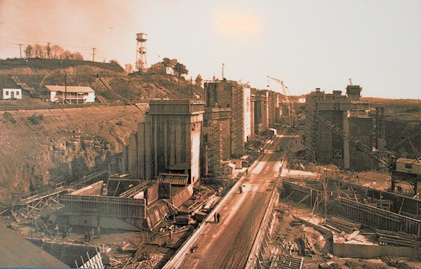
Kentucky Dam during construction.
The Tennessee Valley Authority (TVA) began constructing a series of dams on the Tennessee River to provide flood control, cheap hydroelectric power and recreational opportunities for the people of the Tennessee Valley from Paducah to Knoxville.
The last dam to be built on the Tennessee River, and the largest, was Kentucky Dam. Construction began in 1938 with the completion done in 1944. During the process, entire towns, families, homesteads, farms and infrastructure had to be relocated for the permanent flooding of the Tennessee River.
Birmingham, Kentucky was one of those towns directly impacted. Located right on the banks of the Tennessee River in Marshall County, the town of a few hundred, for some reason, did not relocate and was simply abandoned. Now the old roads and foundations of the town are under several feet of water in the middle of Kentucky Lake.
Cemeteries were also relocated – although some graves were not. Some major US Highways had to be reconstructed and moved. Major rail lines were also relocated or moved to higher ground. It was a big undertaking.
US Army Corp of Engineers decided the Cumberland River would need to be dammed near the site of Kentucky Dam on the Tennessee River. Due to extensive flooding of the Cumberland and also to help with navigation on the river, the Corps built a dam – Barkley Dam – and finished it in 1964.
Similar to Kentucky Dam where the lake was created, the situation forsome small towns was the same as Birmingham. The towns had to relocate or be faced with extinction. Thankfully, those two towns moved a bit up to higher ground.
Today Lake Barkley provides hydroelectric power to thousands of homes and businesses. Lake Barkley features great boating recreation and fishing opportunities for residents and tourists up and down the lake.
The Land Between the Lakes (LBL) began during and after the creation of Lake Barkley, authorities at the time saw that a large peninsula of land would be created and decided to create a massive 170,000-acre recreation area known as the land between the lakes. However, several hundred families and many communities would have to be relocated out to create the National Recreation Area.
For some, this was the second time they had to move thanks to the government – once with the flooding of the rivers, and twice with the creation of LBL. The last of the families left in 1969.
So basically the Cumberland River, at this area, was flooded to create Barkley Lake and the Tennessee River was flooded to create Kentucky Lake all to regulate natural flooding of the rivers and to gather the hydroelectric power that could be generated with dams.
As we watch charts we see underwater notations for old roads, highways, structure. The main channel is very wide as they have dredged over the years and the use of barges and tows keeps it well kept. The lake is very beautiful with the fall colours, black water and blue skies. Traveling south on Kentucky Lake there is wildlife again. Blue Herons and Osprey are back. Even the odd white pelican graces us with his presence as he migrates.
We are anchoring in a bay across from Harmon Creek. We were attempting to drop the anchor in Harmon Creek but our depth readings were off by 5-10 feet. With the low water and the lowering of the waters by the authorities for the winter months some anchorages on the lake are not usable. We find our way back out and scout out another anchorage on the other side of the main river/lake. Anchoring in 15 feet and sending out a good amount of chain we are all snug for the night.


